NATIONAL MARINE PARK OF ALONISSOS NORTHERN SPORADES
The National Marine Park of Alonissos Northern Sporades was the first marine park established in Greece and is currently the largest marine protected area in Europe (2.265km2). Besides the sea area, the Park includes the island of Alonissos, six smaller islands (Peristera, Kyra Panagia, Psathoura, Piperi, Skantzoura and Gioura), as well as 22 uninhabited islets and rocky outcrops.
After a period of internal and external migration, the population of Alonissos has been showing a small but steady rise over the last decades, but not exceeding 2,000 permanent residents. The main occupations of the inhabitants are agriculture farming, livestock farming and fishing, while tourism has been booming in recent years. The establishment of N.M.P.A.N.S. is expected to play an important role in the sustainable development of the region, offering new job opportunities while supporting the local traditional professions.
The area shows a great scientific and cultural interest. In the wider area of the Park there are findings dating back to the Prehistoric era, the Classical period and Byzantine Empire (shipwrecks, old monasteries and churches).
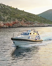
In the areas where public access is permitted, visitors can engage in swimming, diving, wildlife watching, taking pictures, recording video, visiting cultural monuments, hiking etc.
There are specific restrictions on sport fishing. Hunting is allowed only on the island of Gioura, subject to a special permission.
History

The Management Body of the N.M.P.A.N.S. is responsible for the management of the Marine Park and its daily operation. Effective protection of the Park is a challenge for the Body.
The daily operational program directs the field actions and the everyday activities of the Body that are necessary for the effective management of the Park. The everyday operation, with the guidance and supervision of the Body’s Governing Council, is implemented by the scientific and technical staff of the Body in collaboration with non-governmental organizations, universities, public authorities, professional organizations and the local community. The protection of the special characteristics and details of the Park from illegal activities is also achieved with the cooperation of the Port Authorities of Skopelos and Alonissos. The staff of the Management Body consists of 6 people, and the office of is placed in Patitiri. .
The staff of the Management Body achieves the effective management of the Park through monitoring, supervision and patrol of the Marine Park, informing visitors, protection of natural resources and research.
The Daily Management Program also aims to inform Park users by providing specific information according to the needs of the different users.
The staff also provides information to visitors, schools, professionals, etc., about the day-to-day operation of the park and the current regulatory measures.
Operation & Management
The National Marine Park of Alonissos Northern Sporades was the first marine park established in Greece and currently the largest protected marine area in Europe. The efforts to protect this area began in the early 1970s. In 1986, the Prefecture of Magnisia signed the first resolution aiming to the protection of the Mediterranean monk seal (Monachus monachus) and its natural habitat.
These efforts were followed by a series of ministerial decisions on the protection of the local nature reserve. In May 1992, the area was finally declared as “National Marine Park” by presidential Decree. Finally, in June 2003, a Joint Ministerial Decision introduced the management framework for the region and created the Management Body, which becomes responsible for the preparation and implementation of the Management Plan of N.M.P.A.N.S.
The Governing Council of the Management Body of N.M.P.A.N.S. is composed of ten (10) members, who represent national, regional and local authorities, local professional associations and non -governmental environmental organizations. In 2010, Professor Stefanos Paraskevopoulos, University of Thessaly, Department of Special Education, was appointed Chairman of the Council.
Funding for the Management Body has been secured by the Operational Program “Environment” (EPPER). In May 2007, for the first time, 11 properly trained scientists and technical staff were hired, registered in Alonissos, for the implementation of protection and research programs, as well as public awareness and sensitization campaigns. A five-year management plan was also in course of preparation.
The National Marine Park of Alonissos Northern Sporades is member of the MedPAN (Network of Marine Protected Areas in the Mediterranean).
The Park


Aerial Tour
Zones

ZONE A
Permitted activities:
-
Scientific Research with permission and under specific conditions.
-
Surveillance, guard, monitoring, research and management actions implemented by the Management Body.
-
Traditional agriculture farming activities, provided that the interested parties have obtained the necessary permits and according to certain requirements, special conditions and restrictions per region.
-
Traditional livestock farming activities, provided that the interested parties have obtained the necessary permits and according to certain requirements, special conditions and restrictions per region.
-
Professional fishing (coastal and middle) under special restrictions listed below.
-
Sport fishing (only fishing lines and trolling) under special conditions and restrictions as described below.
-
Landings during the mooring process, in areas where vessels may be approached and anchored.
-
Yachts entry, passengers transport and recreational activities (swimming, diving, underwater observation of fauna and flora, photography and video shooting, hiking, landings, overnight on boat and wildlife observation) subject to certain requirements, special conditions and restrictions as described below.
Prohibited activities:
-
Hunting, except on the island of Gioura and only with a special permission.
-
Free camping and use of fire within the entire terrestrial area of the Marine Park.
-
Diving with respirators.
-
Shellfish and sponge fishing.
-
The collection of animals and plants.
-
The speargun fishing.
-
Speed boats to surpass the 10 n.m./hour limit within 0.5 nautical miles from the coasts of the islands of Zone A (where access is permitted).
-
The passage of tankers carrying more than 500 tonnes of oil and any vessel carrying dangerous toxicants.
PARTICULARLY
Piperi Island (Zone A1)
Permitted:
-
Scientific Research.
-
Maintenance of the existing church and related buildings.
-
Traditional livestock farming, provided that the interested parties have obtained the necessary permits and according to certain requirements, special conditions and restrictions applicable to the island.
Prohibited:
-
Approach of any vessel less than 3 nautical miles from the coast of the island with the exception of the vessels used in permitted activities.
Psathoura Island (Zone A2)
Permitted:
-
Scientific Research.
-
Yachts can be reached and moored between sunrise and sunset only on the beach of Mandraki. Visitors are allowed to disembark and use the beach within 50m of the coast. Swimming, diving, underwater observation, photography and video shooting, hiking and wildlife observation are allowed.
-
The maintenance of the existing lighthouse and related buildings.
-
Approach and anchor of professional fishing boats (middle and coastal) and overnight (onboard) around the island.
-
Coastal professional fishing in accordance with the national legislation about the fishing and the special regulations of the NMPANS (terms on fishing gear used and time spent at sea).
Prohibited:
-
Middle professional fishing less than 1.5 nautical miles from the coast for the purse seines and less than 2 nautical miles from the coast for the fishing trawlers.
-
Sport fishing less than 1.5 nautical miles from the coast of the island.
-
Free camping, use of fire and speargun.
Gioura Island (Zone A3)
Permitted:
-
Scientific Research.
-
Maintenance of existing buildings and related infrastructure owned by the Forestry Office.
-
Activities of the Ministry of Agriculture for the conservation of the island’s livestock.
-
Coastal professional fishing in accordance with the national legislation about the fishing and the special regulations of the NMPANS (terms on fishing gear used and time spent at sea) on all coasts of the island except of Pnigmenos Bay.
-
Approach, anchor and overnight (onboard) for professional fishing vessels (coastal fishing only) anywhere around the island, except for the bay of Pnigmenos.
-
When a visit to the “Cyclops” Cave is allowed, access and anchor of professional tourist vessels and yachts will be between sunrise and sunset at the Megali Vala and Sykies points. Passengers will only be able to visit the “Cyclops” Cave.
Prohibited:
-
Middle professional fishing less than 1.5 nautical miles from the coast for the purse seines and less than 2 nautical miles from the coast for fishing trawlers.
-
Free camping, use of fire and speargun.
-
The approach and anchor of professional tourist vessels and yachts.
-
Sport fishing less than 0.5 nautical miles from the coast of the island.
Kyra Panagia Island (Zone A4)
Permitted:
-
Scientific Research.
-
Traditional agriculture farming activities, provided that the interested parties have obtained the necessary permits and according to certain requirements, special conditions and restrictions applicable to the island.
-
Traditional livestock farming activities, provided that the interested parties have obtained the necessary permits and according to certain requirements, special conditions and restrictions applicable to the island.
-
The approach and anchor of professional tourist boats and yachts between sunrise and sunset on the beach of Monastiri. Visitors can visit the Monastery of Panagia using only the trail leading from the beach to the Monastery. Overnight in the Monastery is allowed after the agreement with the monks.
-
Approaching, anchoring and overnighting (onboard) of professional tourist vessels and yachts in Agios Petros and Planitis bays. Visitors are not allowed to disembark (landings are allowed only during the mooring process). Swimming, free diving, underwater observation, photography and video shooting and wildlife observation are allowed.
-
Maintenance of the existing Monastery and related buildings.
-
Coastal professional fishing in accordance with the national legislation about the fishing and the special regulations of the NMPANS (terms on fishing gear used and time spent at sea) around the island with the exception of the area between Vromopigada Bay and the south end of the northwest coasts of the island Fargo.
-
Approach, anchor and overnight (on board) of professional fishing boats (coastal fishing only) around of the island with the exception of the area between Vromopigada Bay and the south end of the northwest coasts of the island Fagro.
-
Approach, anchor and overnight (on board) of middle professional fishing boats only in bays Agios Petros and Planitis.
-
Sport fishing (only fishing lines and trolling) except of the northwest coasts of the island from Katergo to the south end of the northwestern coast of the island Fagro at a distance of 1/3 nautical mile.
Prohibited:
-
Middle professional fishing less than 1.5 nautical miles from the coast for the purse seines and less than 2 nautical miles from the coast for fishing trawlers.
-
Free camping, use of fire and speargun.
Skantzoura Island (Zone A5)
Permitted:
-
Scientific Research.
-
Traditional agriculture farming activities, provided that the interested parties have obtained the necessary permits and according to certain requirements, special conditions and restrictions applicable to the island.
-
Traditional livestock farming activities, provided that the interested parties have obtained the necessary permits and according to certain requirements, special conditions and restrictions applicable to the island.
-
The approach and anchor of professional tourist vessels and yachts in Limani Bay between sunrise and sunset. Visitors can disembark and use the beach. Swimming, free diving, underwater observation, photography and video shooting and wildlife observation are allowed.
-
Maintenance of the existing Monastery and related buildings.
-
Coastal professional fishing in accordance with the national legislation about the fishing and the special regulations of the NMPANS (terms on fishing gear used and time spent at sea).
-
Approach, anchor and overnight (onboard) of professional fishing boats (coastal and middle) around the island.
-
Sport fishing (only fishing lines and trolling).
Prohibited:
-
Middle professional fishing less than 1.5 nautical miles from the coast for the purse seines and less than 2 nautical miles from the coast for fishing trawlers.
-
Free camping, use of fire and speargun.
Korakas, Skantili, Polemika Islets (Zone A6)
Permitted:
-
Scientific Research.
-
Coastal professional fishing in accordance with the national legislation about the fishing and the special regulations of the NMPANS (terms on fishing gear used and time spent at sea).
-
Approach, anchor and overnight (onboard) of professional fishing boats (coastal and middle) around the islets.
-
Sport fishing (only fishing lines and trolling).
Prohibited:
-
Middle professional fishing less than 1.5 nautical miles from the coast for the purse seines and less than 2 nautical miles from the coast for fishing trawlers.
-
Free camping, use of fire and speargun.
-
The approach and anchor of professional tourist vessels and yachts.
All the other islets and rocky outcrops of Zone A (Zone A7)
Permitted:
-
Scientific Research.
-
Traditional agriculture farming activities, provided that the interested parties have obtained the necessary permits and according to certain requirements, special conditions and restrictions applicable to the islets.
-
Traditional livestock farming activities, provided that the interested parties have obtained the necessary permits and according to certain requirements, special conditions and restrictions applicable to the islets.
-
The approach and anchor of professional tourist vessels and yachts between sunrise and sunset. Visitors can disembark. Visiting the church of Panagia on the islet of Pappous is allowed. Swimming, free diving, underwater observation, photography and video shooting, hiking and wildlife observation are permitted.
-
Coastal professional fishing in accordance with the national legislation about the fishing and the special regulations of the NMPANS (terms on fishing gear used and time spent at sea).
-
Approach, anchor and overnight (onboard) of professional fishing boats (coastal and middle) around all the islets.
-
Sport fishing (only fishing lines and trolling).
Prohibited:
-
Middle professional fishing less than 1.5 nautical miles from the coast for the purse seines and less than 2 nautical miles from the coast for fishing trawlers.
-
Free camping, use of fire and speargun.
Pagos Reef (Zone A8)
Permitted:
-
Scientific Research.
-
Coastal professional fishing in accordance with the national legislation about the fishing and the special regulations of the NMPANS (terms on fishing gear used and time spent at sea).
Prohibited:
-
Middle professional and sport fishing within a radius of less than one (1) nautical mile from the highest point of the reef.
The rest of the marine area of Zone A (Zone A9)
Permitted:
-
Scientific Research.
-
Coastal professional fishing in accordance with the national legislation about the fishing and the special regulations of the NMPANS (terms on fishing gear used and time spent at sea).
-
Sport fishing (only fishing lines and trolling).
-
Passage of all professional tourist vessels and yachts. Vessels may exceed the speed limit of 10 n.m./hour only when they are more than 0,5 nautical miles from the shores of all the islands of Zone A.
Prohibited:
-
Middle professional fishing less than 1.5 nautical miles from the coast for the purse seines and less than 2 nautical miles from the coast for fishing trawlers.
ZONE B
Permitted activities:
-
Scientific Research with permission and under specific conditions.
-
Surveillance, guard, monitoring, research and management actions implemented by the Management Body.
-
Traditional agriculture farming activities, provided that the interested parties have obtained the necessary permits and according to certain requirements, special conditions and restrictions per region.
-
Traditional livestock farming activities, provided that the interested parties have obtained the necessary permits and according to certain requirements, special conditions and restrictions per region.
-
Coastal professional fishing in accordance with the national legislation about the fishing and the special regulations of the NMPANS (terms on fishing gear used and time spent at sea). Also fishing with traps in accordance with the legislation in force and up to 100 traps per professional fishing vessel.
-
Middle professional fishing in accordance with the present national legislation about the fishing and the special regulations of the NMPANS (distance from the coast of the islands).
-
Sport fishing (only fishing lines and trolling) and according to the rules of sport fishing applicable to the Greek seas.
-
All recreational activities are governed by the national law, and not by additional specific regulations of the NMPANS.
-
All other human activities in accordance with national law with the exception of activities in Zones B2, B3 and B4 listed below.
Prohibited activities:
-
Free camping and use of fire within the entire terrestrial area of the Marine Park.
-
The passage of tankers carrying more than 500 tonnes of oil and any vessel carrying dangerous toxicants.
The marine zone between Cape Kalamos and Cape Amoni at 200 m from the coast (Zone B1)
Permitted:
-
Coastal professional fishing in accordance with the national legislation about the fishing and the special regulations of the NMPANS (terms on fishing gear used and time spent at sea).
-
Sport fishing (only fishing lines and trolling) and according to the rules of sport fishing applicable to the Greek seas.
-
Approach, passage, and anchor of coastal professional fishing vessels, tourist professional boats and yachts.
Prohibited:
-
The approach and passage of middle professional fishing vessels.
-
Overnight of all boats.
-
The passage of vessels at speeds exceeding 10 n.m./hour less than 200 m from the coast of the island.
Bay of Gerakas (Zone B2)
Permitted:
-
The mild forms of non-intensive agriculture and livestock farming activities.
-
The maintenance of existing infrastructure, the operation of the Research Station and the Fishing Harbor of Gerakas.
The wider terrestrial area of Gerakas Bay (Zone B3)
Permitted:
-
The mild forms of non-intensive agriculture and livestock farming activities. Changing the methods and conditions for carrying out these activities requires the approval of environmental terms.
-
The construction of buildings and related facilities with special restrictions.
The rest of marine and terrestrial area of Zone B (Zone B4)
Permitted:
-
All activities in accordance with the national law and which are not governed by specific regulations of the NMPANS. The only exception is the construction of large projects and infrastructures, which require special authorization and approval.
-
Professional trap fishing in accordance with the present legislation and up to 100 traps per professional fishing vessel.
Characterization of the land and sea areas of Northern Sporades as National Marine Park (FEK No. 621/19.6.203)
Supplementary declaration of the whole island of Kyra Panagia, Municipality of Alonissos N. Sporades and the environment of this declared Marine Park of N. Sporades as an archaeological site (FEK No. 660/4.8.87).
Approval of the definition of a marine archaeological site of Northern Sporades – Alonissos (FEK No. 1741/3.8.2011)
Underwater fishing
According to the decision of the 6th meeting (28.7.2011) of the Governing Council representing the Management Body of N.M.P.A.N.S., underwater fishing is allowed ONLY in the areas designated by FEK No. 1741/3.8.2011 as:
-
Area 1: The coastline to the north of Steni Vala (Alonissos Island), from the cape Apithmenos to the area located to north of the beach of Ag. Dimitrios (Alonissos Island).
-
Area 4: The bay of Spartina (Alonissos Island).
-
Area 11: The bay of Klima (Peristera Island).
-
Area 13: The coastline to the east of the island of Megalos Aderfos.